The network of rivers in Montenegro is strongly affected by the latitudinal arrangements of the landforms. The mountain chain of the Dinarides (the Dinaric Alps) that extends in a southeast-northwest direction, parallel to the current shore of the Adriatic Sea coast, dominates in the relief of Montenegro. The direction of the mountain chains in Montenegro and a strong altitudinal gradient in a southwest to northeast direction are the major barriers to surface runoff that modify the direction of the flows. In the Adriatic basin, groundwater flow, which generally mirrors the surface water flow, flows to the south and southwest, while the groundwater regime in the Danube basin flows to the north and northwest.
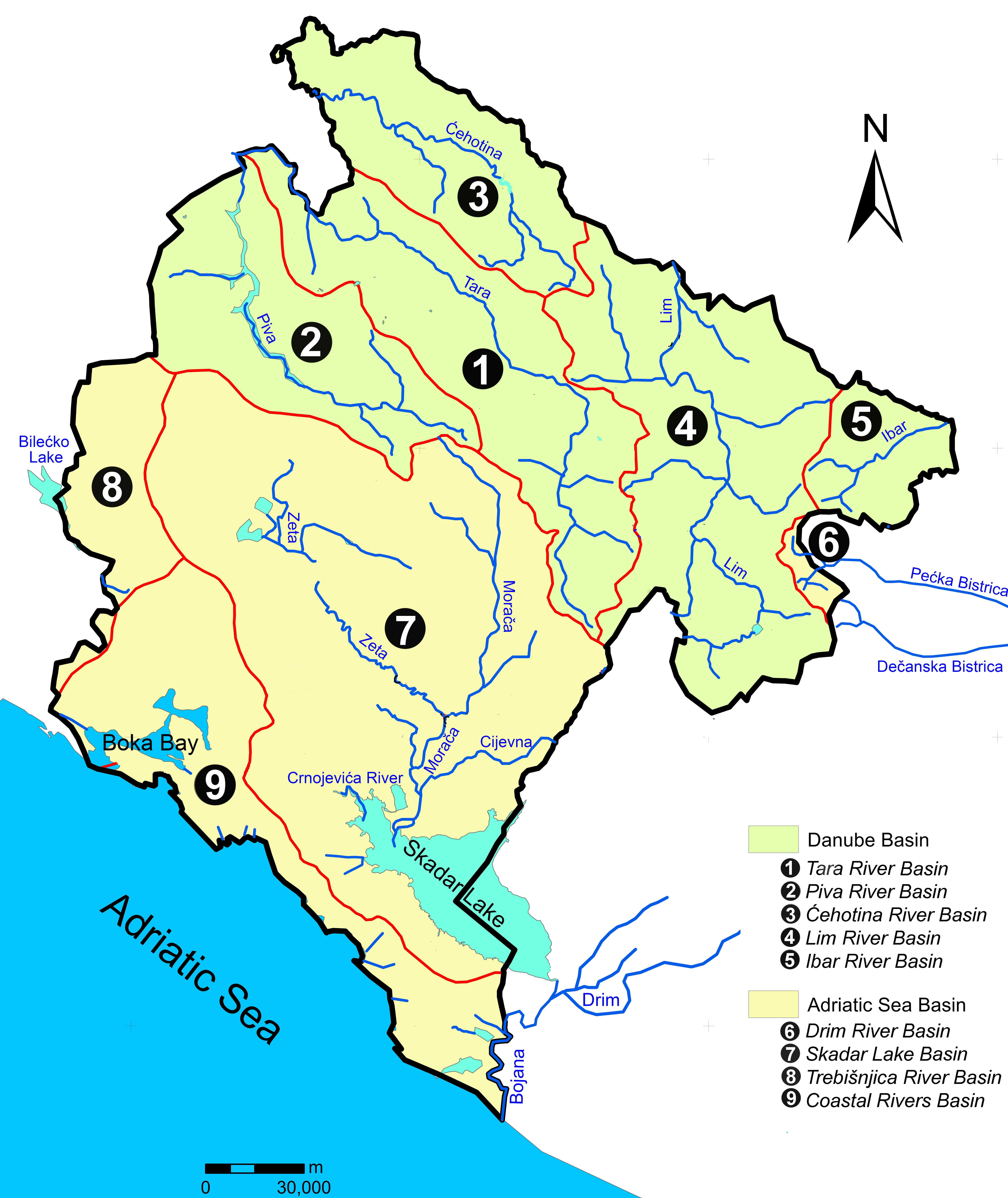
Figure 1 Map of Montenegro with its main river basins (Pešić et al. 2020)
Geological processes in the karst have had a decisive influence on hydrology and the formation of the hydrographic network. From the territory of Montenegro, surface and groundwater flow into both the Black and Adriatic Seas, with approximately 45.4% (about 6,268 km2) of its surface belong the Adriatic basin and around 54.6% (about 7,545 km2) to the Black Sea (Danube) basin.
The terrain along the drainage boundaries is mainly formed by the Mesozoic carbonate sediment that builds the famous karst terrains of the Dinarides, which leads that the hydrological drainage boundaries between the Adriatic and Black Sea’s basins are mostly underground. This makes it difficult to define the drainage boundaries between individual catchments, especially between smaller basins in the holokarstic terrain (e.g., between Trebišnjica and Boka Kotorska Bay on the one hand and the basin of the Nikšić polje on the other).
Montenegrin rivers are characterized by a complex flow regime that depends on the climatic conditions and morphogenetic zones from where these rivers flow. Most of the rivers of the Black Sea basin are characterized by large flows in the spring (April and May) and late autumn (November and December) with their minimum flows coming between August and September. The rivers in the Adriatic basin, which are closer to the sea, exhibit their highest flows in November and December. On the upper part of the Morača and the Zeta, the greatest water flow was recorded in the spring.
There is considerable variability in the flow between different basins. The River Ćehotina has the most stable average annual flow, while the Ibar exhibits the greatest variability. On the temporal scale, the variability of monthly flows is greatest in the autumn. Moreover, a considerable difference in the river density between the basins was found, in that the river network is denser in the Black Sea basin and less dense in the Adriatic one. The contribution of surface runoff to the river basin discharge varies both spatially and temporally. Underground water drainage is the main factor that affects the stability of the water in the karstic terrain. Most rivers and streams in the Adriatic basin dry up in the summer months as a result of the fact that field evaporation exceeds precipitation in this period of the year.
Reference
Pešić V, Paunović M, Kostianoy V (2020) The rivers of Montenegro – introductory remarks. In: Pešić V, Paunović M, Kostianoy A (eds) The rivers of Montenegro. The handbook of environmental chemistry. Springer, Berlin, Heidelberg. https://doi.org/10.1007/698_2019_416


